2520
Views & Citations1520
Likes & Shares
On Mar. 14, 2013 at Miyake I., strong inversion layer was at 2000-2200 m. Disappeared cloud area of 50 km diameter by raining was found 2 h after the seeding around between Mikura and Miyake I. The estimated amount of rain was 2.0 m.t.
On Dec. 16, 2013 at Nii I., three line-type clouds developed by the seeding and recognized on the satellite image of Tera at 20 min after the seeding. Three spaces of cloud disappeared were recognized on a satellite image of Aqua around east of Mikura I. at 2 h after. The amount of artificial rain was estimated to be 0.1 m.t.
On Dec. 26, 2013 at Karatsu, the seeding cloud reached to be 3500 m and the cloud depth increased by 150 m from 1250 m to 1400 m. The final distance affected by artificial clouds was over 100 km after 2 h. Amounts of artificial and natural rainfalls were both estimated to be 0.15 m.t. each after 2 h. Estimations of artificial rainfall by radar echo and surface rainfall agreed with each other.
On Dec. 27, 2013 at Saijo, natural clouds almost disappeared were stimulated and developed by the seeding. Rains of 20 points seemed to be artificial rain due to the seeding time, location, wind direction of WNW, and wind speed. The main zone of artificial rain was 90 km from Saijo to Sugeo. The amount of artificial rain was estimated to be 1.3 m.t.
The seeding rate is about 5 g/s. Convective or stratus clouds are efficient. Seeding air temperature is around -5℃. Depths of cloud are 1000-3000 m. It is important for topographical effect, convective air layer, upstream and wind speed.
Keywords: Artificial rainfall, Aircraft seeding, Convective cloud, Freezing temperature, Liquid carbon dioxide (LCD)
However, these methods present a small amount of water. An artificial rainfall technique of LCD was invented by Fukuta [1,2], and was proven successful at Fukuoka in 1999 as the first effective rainfall production. There were successful results on Feb. 2 and Oct. 27, 1999 [3,4], Feb. 4 and Nov. 7, 2006, Jan. 8 and 17, 2007, Jan. 24, 2009 [5,6] etc.
Main objectives of this paper are that direct and indirect effects by the seeding are made clear as meteorological and topographical effects.
Recent successful results were on Feb. 26-27, 2012, Mar. 14, Dec. 15-16 and Dec. 26-27, 2013 [7-17]. The experiments were done 6 times over the ocean near Miyake and Mikura I. in the Izu I [7-17] and 2 times near lands at Karatsu in Kyushu and Saijo in Shikoku on Dec, 26-27, 2013 [11,12,16], as an example of complex terrain. We are interested in the evaluation of the topographic effects of inland terrain and mountains [11,12,16]. The distances artificially affected by LCD seeding were over 100 km (W-E direction) around Miyake and Mikura I. on Feb. 27, 2012 [7,8] and Karatsu, Saga to Fukuoka and Yamaguchi regions on Dec. 26, 2013 [17,18], and near 100 km at Saijo, Ehime to Sugao, Tokushima on Dec, 27, 2013 [11,12] and at Nii I. to the east of Mikura I. on Dec. 15-16, 2013 [15]. There were several reports and books as other references [5,6,10,14,18,19].
MATERIAL AND METHOD
Principles of the LCD rainfall technique
LCD seeding is done by aircraft, which spreads LCD near the base or bottom of a cloud in a layer of super cooled humid air mass at temperatures below zero. The LCD, at -90℃, instantaneously produces ice crystals (1013 particles per 1 g CO2) [2,3], which collect ambient water vapor and grow to the point of producing snow or rain. This procedure exerts its effects through two processes: (1) air masses with these new ice crystals rise because of the release of heat of condensation and expand in twin cylindrical vortexes as they reach the top of the cloud, and (2) the ice crystals supercool in the clouds, reach to the cloud tops and disperse vertically and horizontally. In addition, the natural updraft in the cloud is augmented by latent heat from the formation of ice crystals. High- humidity air masses are drawn into the cloud from below, causing the cloud to grow. Eventually snowflakes or rain droplets grow large enough to fall to the ground as snow or rain. The development of the cloud is improved when stable air layer lies above it, suppressing vertical convection and promoting its lateral spread. These convective clouds expand by three dimensions of longitudinal, lateral and vertical components. Ice crystals produced by LCD grow actively for up to an hour mainly after seeding, and the artificial rainfall that they induce continues for several hours.
Experimental Method
Case on Feb. 26 and 27, 2012 at Mayake and Mikura Islands, Tokyo
The seeding experiments were conducted on Feb. 26 to 27, 2012 [7,8]. A Beechcraft 200T twine-engine aircraft operated by Diamond Air Service, INC was used for an experiment of seeding of LCD. On Feb. 26, the aircraft was flown from Nagoya to Miyake (Island omits or I. hereafter), where LCD was seeded, and then to Oshima I. On Feb. 27, the aircraft flew from Oshima to Miyake, where LCD was seeded Miyake, and then returned to Nagoya. The wind direction, wind speed, air temperature, and flight speed were monitored by the aircraft’s instruments, and the aircraft position was monitored by our computer using GPS. The LCD was emitted from a nozzle on the base of the aircraft at the seeding rate of 5- 6 g/s. The total weight of CO2 was 6.7 kg in about 20 min. To evaluate the effects of the seeding, we flew around Miyake and Mikura for 1 h, observing rain phenomena and taking photos. We used surface meteorological data, radar data and satellite data issued by the Japan Meteorological Agency (JMA) to model the development and movement of clouds affected by the LCD seeding.
On Feb. 27, there were no high well-developed convective clouds with rain around Miyake and Mikura. The cold air outbreak produced as mixed stratiform and convective clouds (cumulus and stratocumulus). Seeding was done in four bursts lasting about 2, 3, 2 and 2 min at 9:58-10:27. The seeding took place about 5 km west of Miyake. LCD was seeded from south to north at a flight speed of 304 km/h. The seeding height near the base of the main cloud layer was 2130 m for the first seeding and 2290 m for the next three seedlings. The seeding times were about 9 min. There were two layers of cloud. The base of the main cloud layer was at 1830 m and its top was at 2960 m for a total thickness of 1130 m. The second cloud layer was sparse and located at about 1000 m under the main cloud. The thickness of two layers included separated cloud was about 2000 m. The wind direction was SW and the wind speed was 8.2 m/s at 2100 m for all seedlings, and the air temperature was -4.0℃ at 2130 m and - 5.5℃ at 2290 m. The wind direction and speed were W and 8.7 m/s at 3050 m and WNW and 18.5 m/s at 3660 m, respectively.
Case on Mar. 14, 2013 at Mayake and Mikura Islands, Tokyo
The same aircraft in 2012 was used for the seeding of LCD on Mar. 14, 2013 [9,10]. The flight routes during the LCD seeding were the seeding lines of the upper level of north area, about 10 km north of Miyake (Phase 1) and of the upper level of northeast area, about 20 km north east of Mikura (Phase 2).
The seeding rate was about 5 g/s and the seeding was undertaken in two series, each a 10- minute operation. The total weight of CO2 was 6.7 kg. To evaluate the effects of the seeding, we flew around Miyake and Mikura for 1 h.
Phase 1: The seeding area was about 10 km north of Miyake and the direction of WSW to ENE at 2 times of 3 and 3 min and the direction of S to N at 1 time of 4 min which seeding path was like a sign of inequality (≠). The seeding time was at 13:29-13:46. The height of the seeding cloud was 1070 m, air temperature was -2 to -1℃, wind direction was NE and wind speed was 15.4 m/s. The height of top cloud was 1940 m, where air temperature, wind direction and wind speed +2.0℃, WSW and 9.1 m/s, respectively. The height of base of the cloud was 580 m, + 2.3℃, E and 17.0 m/s. The thickness of cloud was rather thin of 1360 m. Phase 2: The seeding area was about 10 km north of Mikura. The seeding of LCD was done as the direction from NW to SE after same as phase 1. The seeding time was at 14:03-14:22. The seeding height was 1070 m and -2 to -1℃, NE, 15.4 m/s. The height of the top cloud was 2060 m, -1.0℃, WSW, 7.7 m/s. The height of the base cloud was 670 m, +5.0℃, ENE and 20.6 m/s. The thickness of the cloud was 1390 m.
Case on Dec.16, 2013 at Nii Island, Tokyo
Seeding of LCD was conducted by the aircraft at the east of Nii on Dec. 16, 2013 [15]. The seeding rate was 3.3 g/s and total seeding weight was 2.5 kg., seeding time 13 min in 9:56-10:14. Observation time at the east of Nii was 40 min in 9:56-10:36. Seeding heights were 1370, 1460 and 1480 m and air temperature was -3℃. The cloud top was 1680 m and its base 1070 m, cloud depth was very thin as 610 m. Air temperature was -1℃, wind direction E and wind speed 1.3 m/s for the first seeding, -3℃, S and 6.2 m/s for the second and -3℃, SW and 8.7 m/s for the third.
Case on Dec. 26, 2013 at Karatsu, Saga in Northern Kyushu
A Cessna T303 aircraft operated by SGC Saga Aviation Co., LTD took off Saga Airport at 12:30 and landed at 14:28 on Dec. 26, 2013 [17]. The wind direction, wind speed and air temperature were observed at 12:32-12:38. The LCD was seeded at 13:35-13:45 in the northern area of Karatsu as shown in Figure 1, i.e., the first (square No. 1) was performed at 13:35-13:37 at 2440 m in height, the second (No. 2) at 13:39-13:41 at 2590 m, and the third (No. 3) at 13:42-13:44 at 2590 m. Arrows 1-3 show the seeding order. Photos of the clouds were taken. A virga (preaecipitatio), i.e., air mass with rain under clouds was observed by eye for about 30 min after the seeding. There were 3-layer clouds; first around 5000 m, second 3350-2100 m and third 2000-1500 m. The seeding was done near the base but not at the base of the second cloud under a temperature of -4.0℃ in the northern area of Karatsu. The seeding was done 1 time at 2440 m and 2 times at 2590 m in a higher density cloud for a total of 6 min from 13:35-13:45 with a seeding rate of LCD of 11.1 g/s and a total mass CO2 of 4.0 kg. The first seeding was from SSE to NNW, the second from NNW to SSE, and the third from WSW to ENE at 10-km distances between each seeding run (Figure 1).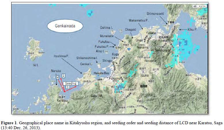
Case on Dec. 27, 2013 at Saijo, Ehime in the Inland Sea of Shikoku
The Cessna T303 aircraft took off from Matsuyama Airport at 10:36 on Dec. 27, seeded LCD at north of Saijo, observed the clouds, took photos after 0.5 h and returned at 12:41 [11,12]. According to the satellite infrared image shown in Figure 2, the density of stratocumulus clouds over northern Shikoku was higher. These clouds were targeted for seeding experiment. At 11:20-11:30, the seeding cloud was partially over 3000 m high near Takanawa Peninsula. LCD was seeded at the height of 1370 m with cloud temperature of - 5.0℃ near the base of the 3000-m high cloud over the seashore of northwest Saijo. Seeding time was at 11:23-11:48 (Figure 2). The total amount of CO2 was 4.9 kg for about 15 min with the seeding rate of 5.5 g/s. After the seeding flight, the author conducted a hearing and research about the surface rain and snow conditions around Saijo and Niihama. The data of surface and upper-level weather radar, satellites, etc. were collected mainly by JMA.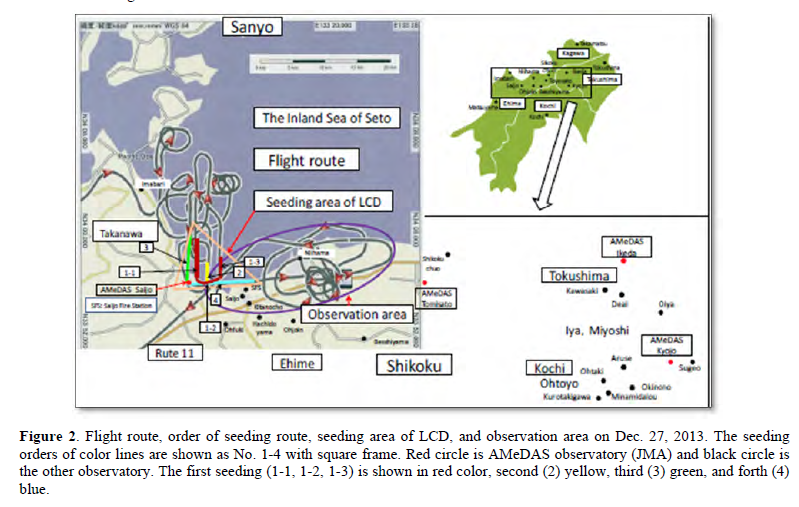
RESULTS AND DISCUSSION
Case on Feb. 26 and 27, 2012 at Miyake and Mikura Islands, Tokyo
On Feb. 26, 2012 [7,8], the development of convective clouds was significant within 1 h of the seeding on the east leeward side of 10 to 20 km from Miyake, reaching a height of 3000 m. Although the LCD seeding succeeded in producing convective clouds, the JMA radar could not detect them because it was limited to elevations above 2000 m, where the artificial cloud was low humid density of vapor and/or volcanic smoke same as on Feb. 27.
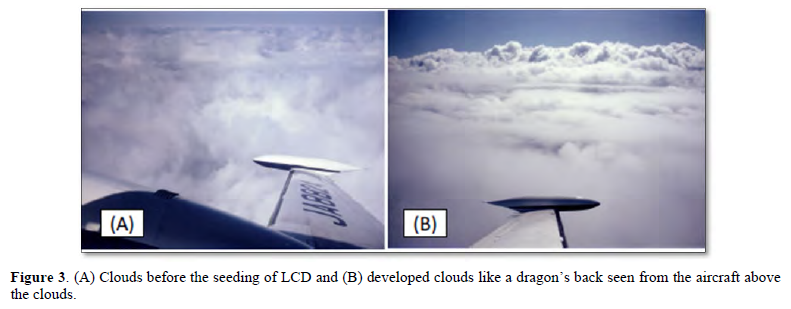
On Feb. 27 [7,8], the seeded cloud moved in a NE direction after the seeding (9:58-10:27) and the artificial cloud appeared. The photos were shown in Figure 3 as undeveloped natural clouds before the seeding and developed artificial clouds with rain at 1 h after the seeding. A cloud developed quickly, the development of convective cloud was significant at the easterly leeward side of Miyake and the artificial cloud reached to the heights of 3500 and 4000 m at 0.5 h and 1 h after the seeding, respectively. The artificial cloud moved further, and it was raining under the cloud recognized by eye. A virga, i.e., the high humidity air mass with rain (direct effect) was also found at a lower layer under the seeded cloud. The virga moved by a NNE-NE wind around 1500 m high and reached around the Westside of Mikura at 0.5 to 1 h after the seeding. We could observe the cloud by eye, and the aircraft flew through and over the cloud. We detected the rain hitting on a front window of aircraft. These convective clouds recognized by eye during a flying were evaluated by the wind direction and wind speed concerned to cloud heights, and the virga.
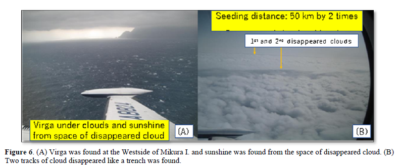
The virga was firstly moved in NE direction by SW wind around the height of 2200 m for 0.5 h, mostly returned buck to the Westside of Mikura by NE-NNE wind of low air layer, and rose up by thermal or upward wind of Mikura based on WSW wind. The cloud developed into a higher cloud by upward wind based on the topography of Mikura (Figure 4). Artificial cloud more developed by the topographic effect. The shape of Mikura is a sharp trapezoid, the area over 500 m is relatively large and the island's total area is 20.55 km2. The highest point is Miyama Mountain at 851 m high. The base of the artificial cloud and the virga were almost same height as the peak of Mikura, and it could easily cover the island. Thus, the mountainous area of Mikura could be covered by rain. These phenomena were agreed with the appearance of topographic cloud and rain [20]. It was rain 1.0 mm until 3 h at Mikura (139 m high).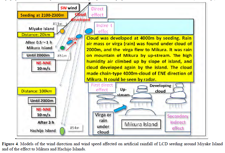
The radar image was shown in Figure 5, there was no image at 10:30 to 11:00, but the cloud developed as an ENE line- or chain-type typically after 11:10 and became high and thick by 11:30 to 12:00 as a secondary (indirect) effect. The clouds could be seen by radar clearly, and the radar echoes reached to be 3000-5000 m. The possibility of artificial rainfall by LCD was very high and remarkable. Such a phenomenon of the clouds appeared in about 1 h and disappeared in about 3 h until 14:00 was an expected result as an artificial effect (Figure 4). If the seeding was not done artificially, these clouds would not be found at all; we presumed and concluded [11,21].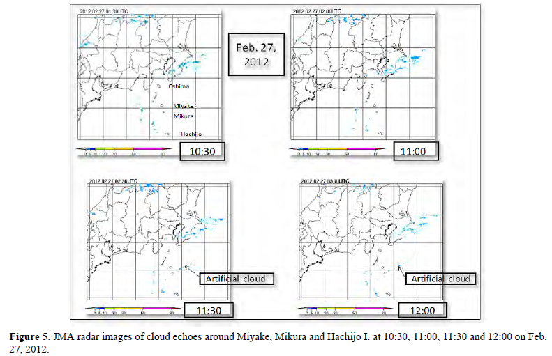
We concluded that the cloud was successfully developed by the seeding. The amount of rain (precipitation) or water was estimated as 1 million ton (m.t.) by the direct effect of seeding around the main area of 10 km width and 100 km length with rain intensity about 2 mm/h. The secondary efficiency of LCD for rain of chain clouds was predicted 3 m.t. per 1 kg LCD as total 20 m.t. So, it was presumed roughly 100 times of rain comparing with old three methods of dry ice, AgI and salt-water seeding [6,22].
Case on Mar. 14, 2013 at Miyake and Mikura Islands, Tokyo
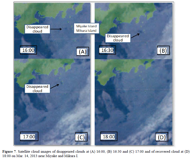
On March 14, 2013 [9,10], the inversion layer was recognized at 1200 to 2200 m, significantly at the level of 2000 to 2200 m. According to Figure 6(A), a virga was found at the Westside of Mikura and sunshine under clouds was seen from the space of disappeared clouds. It was probably rain under the cloud layer from 2000 to 600 m. The cloud was destroyed as an artificial rain, and the width was about 2 km as a flight length of 50 km in a trace during about 20 min. It was interesting result that was found at 2 halls of disappeared cloud at about 1 h latter of seeding, and that the diameter of 1 hall combined from 2 halls of disappeared cloud area was about 50 km after about 2 h shown in Figure 6 (B) and Figures 7(A)-7(C). The wind direction near the base cloud was easterly and the wind speed was strong at 17.0 to 21.0 m/s. The shear of wind direction and wind speed was large at the higher and lower levels. The wind direction at the higher level was westerly wind. The wind direction was NE and wind speed was 15.0 m/s at the seeding height of 1070 m. The amount of rain was presumed about 0.1 m.t. with the rain intensity of 1 mm/h as a disappeared area of 2 km width and 50 km length by after about 1 h as a first affection. The total amount of rain of disappeared cloud was presumed 2.0 m.t. with the rain intensity of 1 mm/h as a disappeared area of 50 km diameter by after about 2 h as a secondary affection. The artificial rain presumed to be successful and the changing efficiency of rain was high.
On Dec. 16, 2013 [16], rain or graupel pellets struck the aircraft front window at 15 min after seeding and a virga or rain under the cloud was observed at 37 min after the seeding under the condition of thinner cloud of 610 m in depth. A cloud developed immediately after the seeding and a line-type cloud running in the NNE-SSW direction was recognized on the satellite image. Afterward, the cloud developed decreased in scale due to rain and the cloud disappeared was also recognized near Nii on a satellite image.
The satellite true color images of Tera at 10:20 and Aqua at 12:45 on Dec. 16 detected by NASA are shown in Figure 8. On the images shown in Figure 8(A) at 10:20 after seeding of about 20 min, there were bright clouds running NNW-SSE near Nii (3-line clouds in Figure 8(A)). On the other hand, 3 parallel lines of bright clouds running in the NNE-SSW direction were recognized south east area of Nii (enlarged figure in upper), those were located in the chain cloud running in the NNW-SSE direction. The images of Bands 7-2-1 (in upper right) was shown as slightly clearer than that of true color (in upper left). The image at 10:20 in Figure 8(A) was taken about 30 min after the first seeding. The clouds were estimated to be artificial clouds produced by 3-time seeding in the NNE-SSW direction based on the seeding time (9:56-10:36), seeding direction, seeding position, wind direction and wind speed.
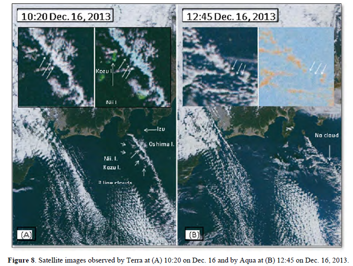
The artificial cloud initially moved in the NE direction due to a SW wind of 8-9 m/s at about 1400 m in altitude and the cloud seemed to move in the SE direction due to the NW wind of 10-15 m/s at a higher level. The wind direction and wind speed at the seeding height were different from those at the intermediate level of seeding height and at the westerly wind height of higher layer. The artificial effect for the cloud disappeared was recognized in the main cloud running to the NNW-SSE direction far-east of Mikura after 2.5-3 h of seeding as a gap or space of 3 no cloud lines in 3 arrows (Figure 8(B), enlarged figure in upper). This is the track of the cloud that disappeared due to artificial rainfall; dropping rain from artificial cloud. The image of normalized difference vegetation index (NDVI) (in upper right) was shown as slightly clearer than that of visible color (in upper left). The artificial affection extended about 100 km from Nii to east of Mikura. The amount of artificial rain was estimated to be 0.1 m.t.
Case on Dec. 26, 2013 at Karatsu, Saga
Development of clouds after seeding and evaluation of clouds by radar
On Dec. 26, 2013 [17], the cloud seeded LCD moved in the ENE direction due to a WSW wind and enlarged more. The height of the cloud top was at about 3500 m according to aircraft observation at 13:50 after 0.5 h of seeding. The cloud depth increased by 150 m from 1250 m to 1400 m.
Radar echoes were shown in Figures 9(A)-9(H) and the radar rain intensity was classified as 1, 5, 10 and 20 mm/h in Figure 9(D). Clouds were observed at heights of 5200-5500 m, 2100- 3350 m (2100-3500 m after seeding), and 1500-2000 m. No cloud was found in a radar image taken at 13:40 (Figure 9(A)) around the seeding area, Karatsu. A virga was observed under the seeded cloud around Itoshima Peninsular. There was still no echo at 14:20 (Figure 9(B)) around Shikanoshima I. (33 km from the seeded area). Small artificial cloud images timely appeared on the radar at Genkai I. and Aino I. (30 & 42 km) at 14:30 (Figure 9 (C)). Radar echoes around Fukutsu to Munakata (Shingu, 50 km, Koga, 52 km) were clearly recognized at 14:40 (Figure 9 (D)). These echoes after 1 h around 50-52 km were almost consistent with the distance that the cloud would have traveled with a wind speed of 13.9 m/s (50 km/h). This is based on the evaluation of the wind direction (WSW), wind speed (13.9 m/s), time (1 h), distance (52 km) and height (3000 m).
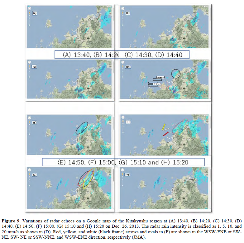
The echoes were assumed to be an artificial cloud with a rain intensity of almost 0-1 mm/h.
At 14:50 (Figure 9(E)), the cloud echoes were significantly wide and moved inland. Moreover, at 15:00 (Figure 9(F)), the echoes had become comparatively wider. At 15:10 (Figure 9(G)), the cloud echoes were observed near Nakama and Noogata, and they then moved from Nakama to Kitakyushu. Given that the cloud development continued until 15:10, it is likely that a good environment was present for the artificial development of ice crystals in natural clouds. Thus, a large amount of rain was produced. The fact that the rainfall continued for over 1.5 h was also consistent with the experimental results [7-17]. However, the echoes had almost disappeared at 15:20 (Figure 9(H)) south of Kitakyushu. Also, the cloud north of Kitakyushu, i.e., the artificial cloud continued to develop to a distance of 90 km at 15:30.
There was a particularly interesting cloud at 15:00 (Figure 9(F)). As the seeding was done north of Karatsu and the wind direction was WSW (red arrow), the artificial low altitude clouds (red oval area) moved in the WSW-ENE or SW-NE direction, and the wind direction and the direction of motion (red arrow and long axis direction of red oval) were the same. However, there were 2 lines of narrow clouds that originated naturally south of Iki I. at 14:30 and east of Iki I. at 15:00. These natural clouds (yellow oval area) extended in the SW-NE or SSW-NNE direction (yellow arrow), and these natural high-altitude clouds themselves moved in the WSW-ENE direction (white arrow). The artificial and natural cloud areas are shown as red and yellow oval areas in Figure 9(G). These clouds extending in the SW-NE direction originated naturally at 14:50 (Figure 9(E)), combined with the WSW-ENE artificial cloud, and moved slightly inland.
Two row clouds seemed to be wider and more significant by the accumulation of each row cloud. However, two combined clouds could be separated based on the different heights of clouds in the second, lower layer and third, lowest layer. The east side cloud became a generally high-intensity cloud due to the combination of natural and artificial layers. The artificial cloud developed in the upper direction as an upstream cloud observed on radar at 14:50-15:00. The principle of cloud development was the upstream in the convective cloud and self-upstream produced by condensation latent heat combined in the connective cloud. The rain cloud area moved from Onga and Nakama to Kitakyushu at 15:10 and then suddenly disappeared at 15:20 due to their consumption as rain. The clouds around the cloud base rapidly decreased after 15:10 or 15:20 (Figure 9(H)).
The clouds almost disappeared with only a small part remained. There was a dry air mass from the continent at 4000 m in the upper layer. As the cloud produced by evaporation from the Tsushima Channel and Genkainada was low in height, almost all rainfall occurred from almost the same height and at the same time. Consequently, the cloud seemed to be drastically decreased around the Kitakyushu area due to rainfall. As downward stream passed through to Onga over the low land west of Kitakyushu, it is thought that the cloud disappeared and the area dried up due to a rain shadow desert climate on the leeward side. These phenomena were interesting in that the properties of the development and disappearance of clouds were similar in Seto [20] and Maki [7-17].
The wind speed was 13.9 m/s (50.0 km/h) around the 3000-m level at 13:00 immediately before the seeding, and the distances moved in Figures 9(G) & 9(H) were 75 km in 1 h 30 min and 83 km in 1 h 40 min, respectively. Thus, the time, distance, direction and speed all agreed. The speed at which the cloud moved in the SW-NE direction from Iki I. to Genkainada was 60 km/h, i.e., the height and speed of the natural cloud were higher than those of the artificial cloud. The rain estimated by radar echo was 1 mm/h in the surrounding area and 2 mm/h in the stronger rain area shown in Figure 9. The artificial cloud in the red oval area was evaluated. The main area of rainfall was estimated to be 50×20 km, and the amounts of rain were 0.2 and 0.3 m.t. at the 1 and 1.5 mm/h expected intensities in Figure 9 (radar echo), respectively. The artificial rainfall shown in Figure 9(F) (red oval) was estimated to be 0.15 m.t. and the natural (yellow) and artificial (red) rains shown in Figure 9(F) (black oval) were 0.15 m.t. each after 2 h [17].
Artificial rainfall and water resources
The amounts of daily rain (AMeDAS) were as follows: Fukuoka (37 km leeward from seeding area), 2.0 mm; Munakata (62 km), 2.5 mm; Iizuka (68 km), 2.0 mm; Yahata (90 km), 2.0 mm; and Shimonoseki (103 km), 0.5 mm. The amounts of hourly rain were as follows: Fukuoka and Iizuka at 16:00, 1.0 mm (natural rain by wind direction), and at 17:00, 0.5 mm, Munakata at 15:00, 0.5 mm, at 16:00, 1.5 mm, at 18:00, 0.5 mm, and at Yahata at 16:00, 2.0 mm. The seeding was done at 13:40, and the peak of rain occurred 1.5 h later (15:10). These phenomena were shown in Figure 9 and the cloud had almost disappeared after 15:20 (Figure 9(H)). The rain at 15:00-17:00 was presumably due to the artificial rainfall because there was almost no other evidence of rainfall at any other time and/or place. An amount of rain 1.0 mm (about half, as in the oval scale in (Figure 9(F)) of 2.0 or 2.5 mm at Munakata and Yahata (1-2 h after seeding, rainfall time 15:00-17:00) and place (leeward side), distance (Shimonoseki 103 km), wind direction of WSW, wind speed of 13.9 m/s and height of 3000 m. A 0.5 mm amount of rain at Shimonoseki was presumably artificial rainfall because it was located at the end of the leeward side, lasted until 17:00, and was the only rainfall in that day. The artificial rainfall spread over a 100-km distance. The distances artificially affected by LCD seeding were over 100 km around Miyake and Mikura [7-10], and near 100 km at Saijo to Sugao [12,13] and at Nii to east of Mikura [16]. The radar rainfall and surface rainfall agree fairly well with each other.
Case on Dec. 27, 2013 at Saijo, Ehime
An artificial rainfall experiment (Figure 2) was conducted at the upper level of air northwest of Saijo on Dec. 27, 2013 [12,13]. LCD was seeded by aircraft at 11:23-11:48 (Figure 10). Figures 10(A)-10(D) show the radar echoes at the time of almost no effect of seeding. We observed clouds from upper air by aircraft. The cloud developed to be a high level of 3000 m based on an enhancement of artificial cloud by LCD seeding. The rain intensity of radar echo was 1-5 mm/h. Image areas of 5-10 mm/h at 11:40 and 11:50 partially increased comparing with that at 11:30. It presumed to be an effect of seeding. The convective cloud quickly changed to rain, and a rather strong rain (5-10 mm/h) was observed in central Saijo around 11:50. A rain cloud was still observed in the southern Niihama over the Shikoku Mountains until 12:00 (Figure 10(E) & 10(F)).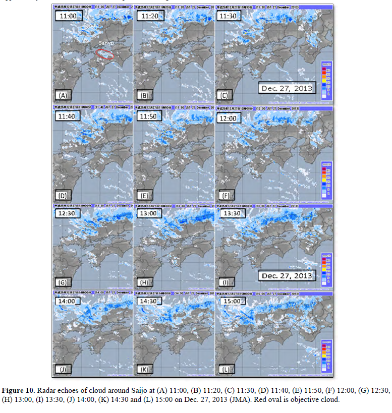
As the cloud finally transformed to rain, after 12:00 the artificial rain cloud resulting from seeding was disappearing, and finally the cloud over the Shikoku Mountains decreased until 12:30 (Figure 10(G)). The rain cloud totally disappeared at 13:00 (Figure 10(H)) in the Shikoku Mountains south of Niihama and Shikokuchuo.
There were no clouds at east of the Shikoku Mountains and Tsurugi Mountains, Tokushima at 12:00-12:30 (Figures 10(F) & 10(G)). However, at 13:00 (Figure 10(H)), a cloud appeared again based on mainly topography of these mountains including Iya Valley with the rain at Deai, Oiya, Aruse, Ohtaki, and Minamidaiou. These rains were explained as virga that changed continuously from higher clouds based on the upward wind by mountains due to the moving of stream for a long distance, and also seemed to be artificial rain with the similar results of the clouds at Mikura in the secondary effect of seeding [7,8] and topographical effects [7,8,20]. The lower clouds developed and could be detected by radar based on the artificial effect in the leeward mountains and valleys.
At 13:30 (Figure 10(I)), the cloud area with 1-5 mm/h enlarged over the mountains and Iya. At 14:00 (Figure 10(J)), the cloud enlarged over the areas with rain at Kurotanigawa, Kyojo and Sugeo. At 14:30 (Figure 10(K)), the cloud enlarged and rain was observed at Kyojo. At 15:00 (Figure 10(L)), rain was observed at Ikeda, Kawasaki, Okinono and Kyojo. These were also artificial rains for the fundamental reasons of the seeding time, seeding area, wind direction, and wind speed.
Actual amounts of rain were observed 0.5 mm at Saijo during 11:50-13:00, 0.5 mm at Ohjoin during 13:00-14:00, 4.0 mm at Besshiyama during 11:50-14:00 and 0.5 mm at AMeDAS Tomisato during 11:50-12:00. The rainfall amounts of AMeDAS were 0.5 mm during 14:20-14:30 at Ikeda, 2.0 mm 13:30-15:00 at Kyojo and Miyoshi, Tokushima and 1.0 mm 13:00-15:00 at 10 points in Miyoshi and Ohtoyo, Kochi. These seemed to be artificial rainfall due to the seeding time, location, wind direction of WNW, and wind speed.
The main line of artificial rainfall was Saijo-Kyojo-Sugeo with the distance of 90 km. The amount of artificial rain was estimated to be 1.3 m.t. [12,13]. Comparing with the results that the amounts of artificial rain or water resources were 1.0 m.t. on Feb. 26 and 20 m.t. on Feb. 27, 2012 [7,8] 2.0 m.t. on Mar. 14, 2013 [9,10] and 0.1 m.t. on Dec. 16, 2013 [16] in Izu I., and 0.15 m.t. at Karatsu on Dec. 26, 2013 [17].
CONCLUSIONS
Case on Feb. 26 and 27, 2012 at Miyake and Mikura Islands, Tokyo
On Feb. 26, 2012, the development of artificial convective cloud was significant after 0.5 to 1 h of the LCD seeding in the easterly leeward side of Miyake and reached to the height of 3000 m, but the JMA radar could not detect them presumably because the artificial cloud was low density and/or volcanic smoke. On Feb. 27, 2012, artificial clouds developed by the seeding were in NE direction of Miyake firstly, and a virga under the clouds moved by NE- NNE wind and reached to west of Mikura 0.5 to 1 h after the seeding. The virga rose up by WSW wind and upward wind, reached at high altitude and developed as secondary artificial clouds. They were recognized on the radar echo. It was observed that the height of chain-type cloud echo reached on 3000-5000 m, when the artificial cloud moved to the ENE leeward side of Mikura. The amount of rain increased on the mountain area. Seeding was effective when done inside convective clouds near their bases under the condition below -5℃. The total amounts of rain were presumed about 1.0 m.t. on Feb. 26 and 20 m.t. on Feb. 27. The artificial rainfall experiments were successful.
Case on Mar. 14, 2013 at Miyake and Mikura Islands, Tokyo
The experiment on Mar. 14, 2013 was successfully shown in as a photo and a satellite image of cloud disappeared by rains based on the seeding of LCD. Inversion layer was at 2000 to 2200 m. The virga was found at the Westside of Mikura. The artificial clouds were disappeared by their rains, and the width was about 2 km with the flight length of 50 km. It was found that the diameter of combined hall of disappeared cloud area was 50 km after 2.5 h latter. The total amount of rain from disappeared cloud was presumed 2.0 m.t. with the rain intensity of 1 mm/h as a disappeared area of 50 km diameter by satellite images. The artificial rain presumed to be successful and the changing efficiency of rain was high.
Case on Dec 16, 2013 at Nii Island, Tokyo
Rain or graupel pellets struck the aircraft front window at 15 min after seeding at Nii and virga or rain under the cloud was observed at 37 min. A cloud developed immediately after the seeding, and three line-type clouds running in the NNE-SSW direction were recognized on a satellite image (Tera) at 20 min after the seeding. Afterward, the cloud developed decreased in scale due to rain, and three spaces of cloud disappeared were also recognized on a satellite image (Aqua) around east of Mikura at 2 h after the seeding. The amount of artificial rain was estimated to be 0.1 m.t. The artificial rainfall experiment was visually successful.
Case on Dec. 26, 2013 at Karatsu, Saga
The height of clouds increased significantly and a virga was observed under the cloud base at 2100 m at 0.5 h after the seeding. The cloud top of the seeding cloud was at 3350 m and the base at 2100 m. The cloud top after 0.5 h was at 3500 m, the base was at 2100 m, and the depth increased by 150 m. At 1 h after the seeding, artificial clouds around Fukutsu and Munakata were clearly recognized, and after 1.5 h the clouds were around Kitakyushu. The final distance affected by artificial clouds was over 100 km after 2 h. The artificial rainfall amounts at Munakata, Yahata and Shimonoseki were estimated to be 1.0, 1.0 and 0.5 mm, respectively. The amounts of artificial and natural rainfall were both estimated to be 0.15 m.t. each after 2 h. The estimation of artificial rainfall by radar echo and the surface rainfall agreed with each other. The artificial rainfall was observed at a target region reached to 100 km leeward and the amount of rainfall ultimately increased.
Case on Dec. 27, 2013 at Saijo, Ehime
After the LCD seeding, convective clouds observed by the aircraft developed quickly above Saijo at 11:30-11:50 and it rained within 20-30 min. Radar echo showed that the natural cloud existed hardly until 11:30. The cloud almost disappeared was stimulated and developed by the seeding of LCD and it changed to a rather strong artificial rain, but the cloud dissipated until 12:30. The artificial snow or rain was significant on the southern mountainous area of Niihama. Amounts of rain 0.5, 0.5, 4.0 and 0.5 mm at Saijo, Ohjoin, Besshiyama and Tomisato respectively were observed in the leeward until 14:00. Amounts of rain were 0.5 mm at Ikeda, 2.0 mm at Kyojo and Miyoshi, and 1.0 mm at 10 points in Miyoshi and Ohtoyo until 15:00. These seemed to be secondary artificial rains due to the seeding time, location, wind direction of WNW, and wind speed. The main zone of artificial rainfall was 90 km from Saijo to Sugeo. The amount of artificial rain was estimated to be 1.3 m.t.
- Fukuta N (1988a) Meteorological Engineering - new method of meteorological control -. Meteorological Research Note 164, Meteorol Soc Jpn pp: 213.
- Fukuta N (1988b) The maximum rate of homogeneous ice nucleant in air by cooling. Proc. 12th Conf. on Nucleation and Atoms Aerosols, Vienna, Springer-Verlag. pp: 504-507.
- Fukuta N, Wakimizum K, Nishiyama K, Suzuki Y, Yoshikoshi H (2000) Large unique radar echoes in a new, self-enhancing cloud seeding. Atmos Res 55: 271-273.
- Wakimizu K, Nishiyama K, Suzuki Y, Tomine K, Yamazaki M, et AL. (2002) Low level penetration seeding experiment of liquid carbon dioxide in a convective cloud. Hydrol Process 16: 2239-2253.
- Maki T, Hashimoto Y, Okushima R, Mitsuno T, Noguchi N, et al. (2008) External Report “Promotion of Artificial Rainfall Technique for Countermeasure of Drought and Prevention of Desertification”. Science Council of Japan pp: 28.
- Maki T, Suzuki Y, Wakimizu K, Nishiyama K (2012) Artificial rainfall from countermeasure of drought to water resource. Gihodo Shuppan, Tokyo, pp: 176.
- Maki T, Morita O, Suzuki Y, Wakimizu K (2013a) Artificial rainfall produced by seeding with liquid carbon dioxide at Miyake and Mikura Islands, Japan. J Dev Sustain Agric 8: 13-24.
- Maki T, Morita O, Suzuki Y, Wakimizu K (2013b) Artificial rainfall technique based on the aircraft seeding of liquid carbon dioxide near Miyake and Mikura Islands, Tokyo, Japan. J Agric Meteorol 69(3): 147-157.
- Maki T, Morita O, Suzuki Y, Wakimizu K (2014a) Artificial rainfall by the seeding of liquid carbon dioxide near Miyake and Mikura Islands of Izu Islands in 2012 and 2013. J Arid Land Stud 24(1): 65-68.
- Maki T, Morita O, Suzuki Y, Wakimizu K, Nishiyama K (2014b) Artificial rainfall experiment by seeding liquid carbon dioxide above the Izu Islands of Tokyo on March 14 in 2013. J Agric Meteorol 70(4): 199-211.
- Maki T, Morita O, Suzuki Y, Wakimizu K, Nishiyama K (2015a) For spread of artificial rainmaking technique of liquid carbon dioxide: Examples of artificial rainmaking experiments carried out in 2013. SCJ FORUM Trend Sci 20(2): 88-93.
- Maki T, Nishiyama K, Morita O, Wakimizu K, Suzuki Y (2015b) Artificial rainfall experiment by liquid carbon dioxide in December 2013 near Saijo area in Ehime. J Arid Land Stud 25(1): 1-10.
- Maki T, Morita O, Nishiyama K, Suzuki Y, Wakimizu K (2015c) An artificial rainfall experiment based on the seeding of liquid carbon dioxide by aircraft on December 27, 2013, at Saijo, Ehime, in the Inland Sea of Japan. J Agric Meteorol 71(4): 245- 255.
- Maki T, Morita O, Suzuki Y, Nishiyama K, Wakimizu K (2015d) Application of artificial rainfall by the aircraft seeding of liquid carbon dioxide for utilization of water resources and prevention of desertification. J Arid Land Stud 25(3): 73-76.
- Maki T, Morita O, Suzuki Y, Wakimizu K (2016a) Comments on the advance line of cloud seeding experiment for precipitation augmentation (Meteorological Research Note 231) and explanation on the efficiency of liquid carbon dioxide seeding. TENKI 63(3): 173- 178.
- Maki T, Morita O, Suzuki Y, Wakimizu K, Nishiyama K (2016b) Artificial rainfall experiment by seeding of liquid carbon dioxide above the Izu Islands of Tokyo on December 15-16 in 2013. J Agric Meteorol 72(3-4): 116-127.
- Maki T, Nishiyama K, Morita O, Suzuki Y, Wakimizu K (2018) Artificial rainfall experiment involving seeding of liquid carbon dioxide at Karatsu in Saga. J Agric Meteorol 74(1): 45-53.
- Maki T (2020) For reduction of global warming and climate mitigation: As an example of artificial rainfall, Road for sustainable society - Seeking goal from environmental science -. Science Council Series. 27: 89-100.
- Nishiyama K, Wakimizu K, Suzuki Y, Maki T, Morita O, et al. (2017) Cloud seeding studies for obtaining atmospheric water resources. Sustainable Water Resources Management, Edited by Chandra S.P. Ojha, Rao Y. Surampalli, Andas Bardossy, Tian C. Zhang, and Chi-Ming Kao, pp: 229-261.
- Ratnam JV, Onishi R (2015) A numerical simulation for artificial rainmaking experiment by seeding liquid carbon dioxide: On the example carried out near Miyake Island on February 27, 2012. SCJ FORUM Trend Sci 20(2): 84-87.
- Seto J, Tomine K, Wakimizu K, Nishiyama K (2011) Artificial cloud seeding using liquid carbon dioxide: Comparisons of experimental data and numerical analyses. J Appl Meteorol Climatol 50: 1417-1431.
- Murakami M, Fujibe F, Ishihara M (2015) Forefront on the research of artificial rain making and snowmaking. Meteorological Research Note pp: 231.


QUICK LINKS
- SUBMIT MANUSCRIPT
- RECOMMEND THE JOURNAL
-
SUBSCRIBE FOR ALERTS
RELATED JOURNALS
- Journal of Womens Health and Safety Research (ISSN:2577-1388)
- Journal of Biochemistry and Molecular Medicine (ISSN:2641-6948)
- Journal of Genetics and Cell Biology (ISSN:2639-3360)
- Journal of Genomic Medicine and Pharmacogenomics (ISSN:2474-4670)
- Journal of Astronomy and Space Research
- Advances in Nanomedicine and Nanotechnology Research (ISSN: 2688-5476)
- Journal of Veterinary and Marine Sciences (ISSN: 2689-7830)


